#GIS-based land management
Explore tagged Tumblr posts
Visit Tumblr Blog
Explore Tumblr blogs with no restrictions, modern design and the best experience.
Last Seen Tumblr Blogs


Fun Fact
Mobile Tumblr US users spend an average of 4.04 minutes per session on the app.
Text

The Importance of Land Acquisition and Monitoring for Sustainable Development
Land acquisition and monitoring play a crucial role in shaping sustainable development by ensuring that land resources are used efficiently, equitably, and responsibly. Whether for infrastructure development, urban expansion, or agricultural projects, these processes must align with environmental and social goals. As the demand for land increases, the use of advanced tools like land management software, GIS-based land management systems, and land asset management software has become critical for driving sustainable outcomes.
#Land acquisition#Land acquisition process#Sustainable development#Land monitoring#Sustainable land management#Land management system#cyberswift#GIS-based land management#Land use planning#Environmental sustainability#Land records management#Land survey and mapping#Land asset management#Digital land monitoring#victoryofgoodoverevil#Sustainable land practices#Regulatory compliance in land acquisition#Role of technology in land monitoring#land management software#land management solutions#land asset management software#land management system#land acquisition software#land management system software#Land software#Land Allotment Software#Land Information management System#GIS based land management System#GIS based land records management#Land Records Management System
0 notes
Note
Can you tell us anything about the Creature Commandos? I read a brief blurb about them in a book of "Weird War Tales" with other stuff like the GI Robot and the Boy Commandos, but trying to google anything on them just leads to debates as to whether or not they were actually supernatural or some kind of science project.

Oh dammit, James Gunn's little Inglorious Bastards-esque cartoon just came out didn't it? Jokes on you guys though, I actually ordered and read the appropriate books ahead of time! You're not slick!/s
Thank you for providing the image for this one so I don't have to go looking for it. (I truly hope you did not watch the old TV movie this was made for though. My god this poster it the best part of it)
To answer the most pressing question, they're a science experiment. Buckle in because if you thought your opinion of the US Army could not get any lower!
The Creature Commandos were formed in 1941 under the auspices of an outfit known as Project M which was the pot the US Army threw money into with the expectation it would use them to come up with super weapons to end the Nazi threat with no oversight or ethical constraint. They were responsible for the construction of G.I Robot as you mentioned and one of their failed experiments even granted New York native Joan Dale the powers she would use to become Miss America.
The Commandos specifically were the brainchild of one Dr. Myron Mazurksy, a real mad scientist type with the pet theory that the tales of monsters and ghouls making up the bulk of human mythology were the triggers for an kind of evolutionary fear, his hypothesis was that altering subjects through chemical and surgical methods to resemble these monsters of legend would give them an edge on the battlefield. (Of course we know now that these stories are not psychological misinterpretations at all but instead tales of actual beings that really do exist)
The Creature Commandos were made up of four founding members:
Private Warren Griffith was diagnosed with psychological lycanthropy and so was remanded into Project M's custody where he was surgically altered into and actual wolf man with very little conscious control of the time of his painful metamorphosis. He had committed no crime other than being considered psychologically unfit for service.
Pilot Officer Vincent Velcoro, a member of the Royal Air Force convicted of high treason for striking a well connected superior officer. Remanded into American custody without any due process under British military law he was given the choice of a 30 year sentence or experimentation which turned him into a human vampire, forced to drink blood at least once a day and only able to stomach consuming raw meat.
Private Elliot "Lucky" Taylor, a newly minted marine who was nearly killed by a land mine during a war gaming exercise. Surgically reconstructed by Project M his vocal cords were severed by the procedure, his family was told he was KIA and Taylor himself was never consulted about the procedure nor was he allowed to leave after the fact. Again he had committed no crime and was not even unfit for service, simply fed into the mill for the sake of "progress"
and Dr Myrra Rhodes who, when operating upon a wounded soldier within Project M's compound was mutated by a poorly secured batch of mutagen chemicals, transformed into a living medusa. She was also unable to leave military custody and was listed as KIA, losing her entire life due to Project M's negligence.
They were placed under the command of one Lieutenant Matt Shrieve who noted in his later unearthed war journal a personal loathing for his "freakish" subordinates whom he treated with inhuman disdain. Providing for their needs only reluctantly and below the standards of what they would have received in a brig back home. They were sent on what were, frankly, suicide missions, managing to survive time and again based on good luck and the members' trust in one another above all.
A truly demonstrative directive, unearthed by a freedom of information request submitted by their families well after the fact showed that the Creature Commandos were under command from the highest echelon that their existence be kept an absolute secret from the All Star Squadron or any of its members. A personal note, written by a redacted command officer at the bottom of the ledger opines
"The long underwear freaks would just get their bleeding hearts in a twist anyway."
Meaning that the army specifically kept the Commandos a secret from the Squadron, KNOWING that the Squadron would object to the less than human conditions and expectations of the Commandos and most likely would have seen to their emancipation under Squadron protection.
As the war drew to a close, the Commandos were marked for execution by firing squad. No trial or crime was ever given as reason. "Spared" from execution they were sent in a rocket toward the then ongoing battle of Berlin to do some final "good" or die trying.
Their presence is not noted at the battle and their bodies, or indeed their trails have never been found. Make of that what you will.
#dc#dcu#dc comics#dc universe#superhero#comics#tw unreality#unreality#unreality blog#ask game#ask blog#asks open#please interact#worldbuilding#creature commandos#patchwork#wolfpack#dr medusa#vincent velcoro
46 notes
·
View notes
Text
Questions from Interest Check
Hello all! Thanks for all of your interest, and thank you for filling out the Interest Check! We still have quite a bit left until the Interest Check closes, but I figured I would answer a few Interest Check/Ask Box questions now, and answer the rest closer to the end of the Interest Check:
Is traditional art accepted in this exchange? Do art gifts require a specific resolution/file quality/etc?
Yes, traditional art is accepted! Traditional art must be shared via a high-quality scan and/or photograph. We do not have any specific resolution requirements, but as long as it meets the standards of art submissions (Minimum: Colored Sketch Maximum: Colored Full Piece (w/ background)) then it should be fine. During the event, we will have two check-ins, and if anyone has any questions about image quality, etc, you can absolutely reach out to me with any pictures they may have of your work!
Would AUs be allowed? if so, how would it work when submitting the form? For example, If I had an AU I wanted artwork of, would I have to explain what the basis of it was & offer artwork references of the designs if there were any? I would expect including AUs would really complicate things & it wouldn't be allowed for that reason, but I felt it was worth asking anyways
Personally, I think having AUs might be an interesting way to do this years gift exchange. Last year we had a lot of OCs set in the Layton universe, and I think it might be an interesting way to change it up with allowing AUs (We didn't necessarily NOT allow AUs last year, it just didn't come up.) This year, we will have several prompt lines that people can post one prompt each in, and a requirement will be all submissions have to have at least one base canon Layton prompt (which can include ships), just because that will make it infinitely easier to pair people up. If someone were to submit an AU, it would require some sort of pdf or drive file that anyone can access where people can see the jist of the AU with any relevant images. It will also require a short blurb about the AU (that is easy to read- please don't send an essay) with what it's about, and then (if the prompter would like) prompts alongside that. Again, I'm quickly mentioning that the prompter will be required to have an non-AU prompt, just given that it will be hard to pair people up with people who do/ do not want to draw Professor Layton AUs, but I do think its an interesting idea! People who submit AUs will not have a guarantee that their AU will be drawn, but it will certainly be an option that the person who is drawing the gift can take if they want.
If I chose "Crossover Pieces" in 4th question, will I have an opportunity to draw someone's PL OCs too (For example PLvsPW and PL OC/s in it)?
Probably? It really depends where the interest check lands, but right now it's a 50/50 about whether people would like to do just base canon Layton art or include Layton OCs. As mentioned above, I personally think it would be really interesting to do a gift exchange that allows AUs and OCs; however, it will be infinitely more difficult to organize. It really depends on how many people are planning on joining the gift exchange!

No, but we will require at least 2 social medias (which CAN include email) to take part! This is in case we need to contact you via other means. The social medias that will be included will include Twitter, Tumblr, Discord, and Email. The reason for the limit with social media is just to make it a lot manageable for us to pair people together, especially given that we are hosting this on Twitter/Tumblr mainly, and people usually enjoy being able to actually give their gift to their own Secret Buddy (which would require people only on tumblr to be paired with people either only on tumblr or both on tumblr/twitter, etc).
Lastly, I'm going to preface that we will try our hardest with pairing everyone up with the best person possible! Doing so is, of course, a bit difficult given that we primarily will not be pairing spoiler characters/games with people who have not played that game, but we will try our best. We're very excited to see what people create- we had a blast last year with hosting this on Twitter, and we're very excited to host it again!
---
Some smaller updates: We now have a little blurb talking about what a gift exchange/secret santa is on the website! Feel free to check that out if you would like to know what this event is.
We've also set up the Gift Exchange 2024 role on our PLGiftExchange Discord Channel! Please join us here!
Any new questions submitted will be added in a reblog from this post within the next couple days!
~~~
19 notes
·
View notes
Text
Fed community, if you're out there, do you think that the BPRD from hellboy owns land. Like do they have haunted sites they manage. They probably own the land they have bases on. One of them is in Colorado.
I have ideas for a BPRD oc but I'm of course always paralyzed by "what if this isnt accurate enough" type beat.
I'd imagine that if an organization owns land, like the USFS or BLM or heck even the DoD, they have land managers. And if there are trees on that land they probably have foresters. And if they have foresters they probably have GIS workers. You see where I'm going with this?
PARANORMAL GIS/DATABASE MANAGEMENT
Also are they subject to NEPA? Do they need NEPA compliance officers? What kind of paranormal activity might a GIS team be good to have around? At least they need a database management team.
Head's buzzing with ideas. They're most certainly underfunded. Probably worse than the Forest Service. In 2012 they're still working with ArcMap 2004 or something. Probably have someone on call as a "techxorcist" to purge the databases of inevitable evil spirits.
Maybe they have specific python programs to run "pentagram triangulation" or something like that. Someone's gotta figure out if the house is actually bigger on the inside than the outside. Who better than a specialized survey team?
Also what kind of paranormal abilities might people have to land them working in GIS? Probably just weak stuff that makes them less suitable for field ops. Or things that might dissuade them from working at a different federal agency. Like if you have glowing skin maybe you'd be better off working database for the BPRD than for the BLM.
I came up with a silly name: Unit 66
Because of 666, and because a surveyor's chain is 66 feet.
14 notes
·
View notes
Text
I'll go ahead and drop this after sitting on it for so long for @spr-ingo. This is for "Alternator" (AU). A PLA AU based on Yu-Gi-Oh. Feel free to have fun with this idea if you want to do another version.
It is something that has been stewing in my brain for a while but has gotten a bit too big for me. I'll see if I write anything for it. So here it is. Have fun! What spurred this idea was thinking that Emmet would be pissed if some spirit kept possessing him to fight pokemon battles.
Nameless Warden AU
Premise:
This is an au based of the original Yu-Gi-Oh plot. There was no chosen hero sent by Arceus in this timeline. Ingo is still accidentally transported to the past by unknown means. It's coincidental. He is without any prior memory. And is gifted the name Nobori(because it is convenient). Is this plot convoluted to get to a desired scenario? Yes!
In this universe Wardens hold a bit more blessed power in their assignments. The Warden bands(or other catalyst I am open to changing this) connect them to the blessed pokemon and act as a catalyst for Almighty Sinnoh's power. It's not game breaking power but it is things like the ability to be somewhat in tune with the land and its pokemon or predict the future. It's not important. The point is that these artifacts are a direct connection to the primordial powers. Which one is entirely based on who they believe in/ wish to commune with. It is very personal.
Nobori/Ingo is chosen by Sneasler and comes into possession of a sacred band. He is not as adept with the power that is bestowed upon him because he hasn't had as much time with the clan's religion, but he was the only accepted choice. He is still great at his job with his talents with pokemon and instincts so it becomes less of an issue.
Shit hits the fan while Volo spins his web. It is a trial with many injuries, but the Wardens are able to work together and calm the Nobles from their frenzy. Warden Calaba gets injured, her sacred band goes missing and Ursaluna is dying. Volo gets a hold of the item. And uses that to further tap into Giratina's power usurp the Almighty. He manages to frenzy both Dialga and Palkia which destabilizes the Wardens' connection to their chosen deity.
To summarize how the situation is solved: Ingo is less connected to Palkia than his other clan mates and was always more open to the idea of multiple higher beings as it just made sense. He realizes(through various means not touched upon) there must be a larger power other than space, time, and distortion. If he could appeal to this being he could have the power to stop this and possibly contain the distortion in a similar way to how Volo had detained the two Sinnohs. He is able to gain the approval and link to Arceus(a very hard being to appeal to. See Volo) and, through great effort, seals Giratina and the distortion world away using the power of his soul. Volo is seething, of course, that this Nobody has gained approval of Arceus and is using that power to seal them away.
Much like with the Pharaoh in Yu-Gi-Oh it is sealed with his entire soul and his name (which nobody knows not even him) is the key. Ingo's soul, now with amnesia x2, is sealed in his Warden's band artifact as a spirit. His true name is already unknown to everyone, but lore keepers erase his given one as well as many depictions of him from records as well just to be safe. Volo is definitely the Bakura of this plot and was similarly placed in the stolen Ursaluna artifact.
Ingo has been gone 4-7 years. I haven't decided.
The Future:
(warning: it/it's pronouns used briefly due to lack of knowledge. Evolves to they/them then he/him)
Emmet is given a strange box by an old friend of his brother's, Shauntal, who stated that she bought this in Sinnoh from an antique shop because that's just her hobby. They saw each other while at a party that Burgh dragged him to. She says she just feels like it should belong to him, which would be weird if it was not a completely normal thing for her to do. So he accepts with little thought. It's a puzzle box. Perfect he loves a challenge. He feels possessed(metaphorically) to solve it that night. Finds the strange band and wears it with no thought as if he has always had it.
After a while Emmet starts noticing that he is losing time. It's mostly on the Singles line when he is tired and the battles are boring anyway so he pays it no mind, but then It happens once on the Doubles and that is a step too far. He investigates his footage and sees that he is still battling, but with a strange slumped posture and a dour look. The strange thing possessing him is doing well. Even if it makes him look a bit feral. So he is being possessed. He knows that the only change to his person has been that item that was given to him. He doesn't really want to get rid of it for some reason, but it is interfering with his work. He visits Shauntal and demands she uncurses the object. She is surprised that there is such a strong spirit there in the first place. It was dormant and weak when she gave him the box. They must really like him.
They communicate with the spirit and determine that they are just as confused and aren't malevolent. Emmet sets some boundaries that they can stick around as long as it asks before battling in his stead. Heck he might even let them on some occasions like on the boring ass singles line.
TLDR Emmet gets a new spirit friend and learns how to be close to someone again. Slowly the spirit relearns who he is thanks to his new friend.
Also Cynthia uncovers some Hisuian artifacts, including a certain stolen one, so watch out for that.
---
That's the gist of it. There are other versions I was playing with, but this is the one I am liking the best now. Also so many ways that this story can continue that I haven't really thought of.
9 notes
·
View notes
Text
I recently tried tcgplayer as a buyer and here are my thoughts on the website. First, the marketplace is gigantic. There are a ton of sellers and you can find almost any Magic the Gathering card. My review is only about the Magic the gathering aspect of the website as that is my current interaction with tcgplayer. I have been looking at bulk reserved list cards because I want some more of these cards in my collection. The recent spikes with Bloomburrow led me to believe that there is still some interest in old Magic and I have a strange feeling there will be reserved list spikes and buyouts again before the end of 2025. The hype for new mtg is not sustainable. How many valuable or desired cards still do not have a serialized version? How many cards have more than one serialized version already? I think the marvel set will be the apex of this era in mtg and there will be a shift. I think investors and collectors will show an increased interest in reserved list cards and the vintage market. There have been rumors that a version of commander will make its way onto arena by the end of 2025. Could a new arena format influence the card market in paper? If they put a bunch of reserved list cards on arena and people start making decks using, them this could renew interest in older cards. People are going to want to build decks in paper out of their decks on arena. What does any of this have to do with tcgplayer? I was trying to buy large quantities of reserved list bulk. I noticed that tcgplayer has reserved list cards for pocket change. Not only are the base prices lower but there is no limit on the quantity. Website like card kingdom, troll and toad, and starcitygames artificially limit the quantity of each reserved list card you can purchase. That obscures the number of reserved list cards a store actually owns but also prevents buyouts. One person can not buy 100 copies of a reserved list card om starcitygames at one time and in one order. This allows stores to adjust the prices higher if they see interest in a bulk reserved list card. Tcgplayer has no limits. If a seller is selling 100 copies of a card I can buy all 100. However, tcgplayer has a different way of preventing buyouts. Since there are so many sellers, you can find 1000s of copies of any card but it is unlikely that a single seller is selling all of them. This creates situations where the shipping prices for the number of packages makes it non-viable to buyout cards as the shipping for each package makes it too expensive. Tcgdirect is also not a great solution to the problem. 50 dollars is a high minimum for free shipping but I noticed that even when I try tcgdirect, I often find my cards separated into many packages so I do not get all the cards I want. The cart optimization setting is also an absolute joke. I assume tcgplayer makes it purposefully difficult to buyout reserved list cards. Tcgplayer should also increase the minimum quantity number. Typically, I want to search for a reserved list card where a single seller has 20 or more copies and I can only set it to 10 or more copies. Also, tcgplayer should have an option to search reserved list cards as a group like troll and toad. Even so, I did manage to buy over 100 copies of three or four reserved list cards this week on tcgplayer. One seller was selling 102 copies of divine retribution for 10 cents each. I bought every copy! I also bought over 100 circle of despair and over 100 of Land cap, an ice age land. I just wish more sellers sold huge quantities of reserved list cards instead of having just one or two copies.
#magic the gathering#magic the card game#commander legends#youtube#commander#mtg#blogatog#arena#mark rosewater#reserve list#reserved list#tcg#tcgplayer#edh#cedh#edhrec#card kingdom#coolstuffinc#starcitygames#trollandtoad#magic the gathering arena#magic arena#magic card game
2 notes
·
View notes
Text
An Analysis on Card Games
I was asked if I was gonna make a Card Game that wasn't a board game as well. What would it be? So here is an analysis of current battle-type card games.
Typical card games these days have a couple of core mechanics. Permanents and Spells (Ala MTG.) Permanents are typically Damage per Turn (Like creatures) which do damage every turn.
While spells typically due a one time set amount.
Then because that's the core mechanic; the next is damage prevention or damage restoration. And then the next after that is using your "Library" or "Deck" as a secondary health pool.
Running out of library typically means a loss for that player, but not always. (Usually added to avoid dragging out games past both players running out of cards.)
So then you add damage prevention, health restoration, Drawing cards, Restocking your library, discarding, milling (discarding cards directly from the library) all as separate mechanics.
And then you get to the Meta-gane.
The Meta-game interactions start changing how the game is played. Instead of damaging a player directly, for example, you might have two permanents that "talk" with each other, and their interactions deal damage to the player.
And meta-gaming can get ridiculously complicated. But usually, at least today, it gets based around a single card interaction in the "Standard Formats" (or current set list.)
Some games don't have a resource cost to play cards. Other games building resources is a core mechanic. In MTG for example; You play a land per Turn, and each land gives you a set amount of mana you can play for the turn. Stronger spells *typically* cost more.
In Hearthstone; you simply get one more energy resource per Turn until it maxes out at 10. And then--unlike Magic; cards rarely cost more than 10 mana.
Though, even in Magic, players typically don't use cards that cost ten or more because competitive games tend to last at moat ten rounds.
Casual play on the other hand; is a different story.
Players want to be able to play the giant cards with ultimate spells. Which is how Yu-Gi-Oh and other off-main-stream card games were developed. (And subsequently nerfed because it got out of hand too quickly. Less like a game, more like: first turn "I win.")
So what is important here is that most card games are about resource management.
The main resources; Life(damage) Total, Cards in Hand, Cards in Deck, and Mana Generation.
Oftentimes; sub-resources are created as part of the meta-game. Energy Counters (or other Tokens) in MTG, and Corpses in Hearthstone.
In digital games like Hearthstone; Sub-resources could even include "poison" cards thrown into a players deck (and their opposites; anti-poison cards)
And those things are annoying because they trigger an effect when drawn, but not all the time. And mess with your deck totals by obfuscation. You can no longer tell by the indication exactly how many cards are *really* in your library. Forcing a player to memorize how many *fun extras* were added to the deck that don't actually count as *real* cards.
3 notes
·
View notes
Text
Week 2 Blog Post
Describe your ideal role of environmental interpreter. What might it entail? Where might it be? What skills might you need? (Keep these all-in mind as you begin to work on your assignments – tailor these to that ideal job!)
Another week, another blog post:)
Describing my ideal role as an environmental interpreter is a bit of a tough job. I have some ideas of what I might like to do one day but applying interpretation to that can be a bit tricky. For example, recently I have been really into the idea of ‘rewilding’. I hadn’t heard about this concept until a few years back, but the basics of rewilding is to take deteriorated ecosystems and uplift them by reintroducing things like keystone species or reshaping the environment to allow for them to reach their full potential again. Mossy Earth is my main inspiration here and they manage to be incredibly effective interpreters while also doing great environmental work. The video that introduced me to their team was their task of flooding a forest along the Danube River in order to recreate floodplain forests which hadn’t properly functioning for many decades before this.
One of the reasons this was so appealing to me is that it seems to have a great variety of work involved. The team talks about everything from surveying the area to identifying which species in this location could benefit most to physically excavating the land which they wanted to see flooded. This kind of deep involved work is right up my alley, no project would be the same as another but they all result in tangible effects on the environment around you. In the follow up videos you can actually see the forest flooded again and how brimming with life it is! With a relatively low cost this small team has helped restore an ecosystem that was almost inert before their intervention.
All of this ranting is to say that something along these lines would very much suit what I would like to do as an environmental interpreter - giving people a tangible understanding of what we as individuals (or small teams) can do to help the environment. Since this is a very open ended idea of what I might like to do as an interpreter it leaves a million options open as to what I could do or where I could go. Mossy Earth is mainly based in Europe but I’m sure there’s just as many hurting ecosystems in Canada that need attention like this as well. Now, I personally couldn’t see myself making a Youtube channel and trying to attract as many viewers as possible, but maybe something on a smaller scale, like giving guided tours through rewilded areas for example, could be a better way for me personally to interpret nature.
As to the skills I might need for this role, just about everything would be helpful. A deeper understanding of how ecosystems function would be the most broadly useful but skills like using GIS mapping software, finding the right kind of communication to intrigue an audience or sampling rivers for invertebrates would all be skills that would be useful in this sort of venture. In the end I don’t think I would ever truly be done gaining skills for work like this.
I’m excited to see how everyone else views their role as an interpreter and what other people strive to do with their futures as well! Also here's a link to one of the Mossy Earth videos if anyone was interested in taking a look:)
https://www.youtube.com/watch?v=-q7z8sm5UaM
6 notes
·
View notes
Text
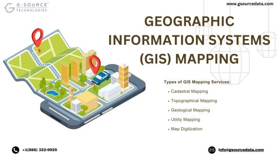
Geographic Information Systems (GIS) mapping services stand as the cornerstone of modern spatial analysis, bridging the gap between geographical data and informed decision-making. This dynamic technology seamlessly integrates diverse datasets onto a unified platform, yielding a comprehensive view of our surroundings. Within this realm, Gsource Technologies emerges as a leading force, offering a suite of GIS services that encompass a wide spectrum of applications.
From cadastral mapping, which aids in land administration and property management, to topographical mapping that captures the intricacies of terrain, Gsource Technologies' GIS expertise is all-encompassing. Their proficiency extends to parcel mapping, facilitating accurate delineation of property boundaries for effective land use planning.
With an eye on technological advancement, Gsource Technologies excels in map digitization, transforming paper-based maps into dynamic, interactive digital formats. Geological mapping, another specialized service, enables the identification and visualization of geological features, crucial for resource exploration and environmental studies.
Gsource Technologies' commitment to GIS services empowers urban planners to craft sustainable cities through spatial analysis, conservationists to safeguard ecosystems, and businesses to make data-driven decisions for growth. Moreover, their involvement in cadastral, topographical, parcel, map digitization, and geological mapping underscores their comprehensive approach to spatial data analysis.
In essence, GIS mapping services, coupled with Gsource Technologies' proficiency, reshape the way we perceive, analyse, and leverage geographical data. This synergy cultivates smarter urban development, environmental stewardship, and informed business strategies, ensuring a more sustainable and interconnected future.
#gsourcetechnolgies#engineeringservices#architecturedesignservices#GIS#geographic information system#cadastral#mapdigitization#architecturedesigns
3 notes
·
View notes
Text
Drones and Surveying in India: Key Players and Industry Insights
The entry of drone technology has revolutionized surveying and mapping in India. With rapid advances in the capabilities of drones, private businesses, government agencies, and industries such as construction, agriculture, and real estate are now employing drones for aerial surveys with high precision. By substituting drones with traditional surveying methods, surveying with drones has enhanced efficiency, accuracy, and cost-effectiveness.
Diversity is vast in India, accompanied by a never-before-demand drive toward feeding this development purpose. Moreover, the proactive measures taken by the government in this regard has added throttle to the application of drone surveys, including the Digital Sky Platform and relaxed drone usage policies. This paper, therefore, delineates the leading drone survey companies in India and smashing on in broader copulation-role aerodynamics in survey applications.
Leading Drone Survey Companies in India
1. Aereo (previously Aarav Unmanned Systems)
Aereo is among the pioneering drone companies in India providing high-precision aerial surveys and geospatial data solutions. It employs drone-based solutions in sectors like mining, infrastructure, and agriculture. Their technology provides precise topographic mapping and terrain analysis, helping optimize land-use planning and resource management.
2. IdeaForge
IdeaForge is among the major regions within India’s drone ecosystem, credited for developing strong, indigenous drone solutions. With the major thrust on defense and surveillance, IdeaForge now has resorts into land surveying and mapping capacities. Equipped with advanced sensors and surveillance, their drones intend for providing unmatched accuracy in topographic surveys in chennai 2 mainly along tough terrains.
3. Skylark Drones
Skylark Drones is a drone solution and services provider from Bengaluru, covering end-to-end in surveying, mapping, and industrial inspection. Armies of GIS data analysis enable clients to make informed business decisions. The cloud-enabled data processing platforms allow access to high-resolution survey outputs with ease.
4. Indrones Solutions
Indrones Solutions specializes in drone-based survey solutions in various sectors like real estate, oil and gas, and urban planning. Using their drones, clients are provided with high-resolution three-dimensional mapping and volumetric analysis which helps in complete land evaluation and monitoring of the environment as well.
5. Marut Drones
Marut Drones are known for their expertise in drone solutions pertaining to environmental and agricultural applications. They developed drones for precision farming, tree planting and smart water management, which speaks volumes about how innovative they have been in utilizing drones beyond the scope of traditional surveyors.
6. Omnipresent Robot Tech
Omnipresent Robot Tech is a key player in the UAV market of India, peddling crop surveying, GIS mapping, and smart city development drones. Their drones are extensively used in large-infrastructure-project planning and management to ensure that land assessments are done with pinpoint accuracy in urban planning issues.
7. DroneAcharya Aerial Innovations
DroneAcharya specializes in mapping, surveying, and offers training for UAV operations. Examining skill development and technological enhancement, its critical role has been towards fulfilling the growing need for an efficient drone ecosystem in India.
8. Asteria Aerospace
Asteria Aerospace is a drone technology co-working drone with industrial applications across land surveying, asset monitoring, and military presentation. Their drone platforms integrated with GIS enable performing real-time data processing and advanced analytics.
Drones and Surveying: The Transformational Impact
1. Advantages of Using Drones in Surveying
Drones are steadily becoming one of the most popular tools for gathering aerial data for surveying and mapping, and they do so with extreme precision. Here are some of their basic advantages over traditional land surveying:
Time Proper: Drones cut survey time by quite a large margin, unlike their traditional land-based counterparts.
High Precision and Accuracy: Use of advanced sensors along with LiDAR and GPS survey a mapping accuracy to the level of centimeters.
Budget-Friendliness: The manpower and equipment cost for carrying out drone surveying is much lower.
Access to Hazardous Locations: Drones able to conduct surveys in areas quite remote and dangerous to perform manual surveys.
Snapshots: AI analytics and cloud computing enable real-time insights for aiding better decision-making.
2. Major Applications of Drone Surveying in India
Drone surveying has gained relevance across several sectors and businesses in India, changing traditionally established methods of carrying out land assessments and infrastructure planning.
a. Infrastructure and Construction
Drones perform a vital role in preconstruction surveys, monitoring progress, and infrastructural inspections and allow the project manager to track phases of construction, detect deviations, and ensure conformance to the design.
b. Agriculture and Precision Farming
Drones equipped with multispectral cameras give an elaborate analysis of the health of crops, moisture content in the soil, and pest infestations. This kind of info helps farmers reduce their input cost and enhance productivity by applying precision agricultural practices.
c. Stone Mining and Quarrying
Drones are used in mining companies for volumetric analysis, land reclamation planning, and safety audits. Drones help in accomplishing stock monitoring, volume excavation calculations, and ensuring conformity to regulatory obligations.
d.Urban Planning and Smart Cities
Municipalities and urban planners use drones for mapping city layouts, monitoring infrastructure developments, and planning transportation networks. Drones support the provision of live data for better city planning and disaster management.
e.Environmental Monitoring and Disaster Management
Drones assist environmental assessments, afforestation initiatives, and disaster relief efforts. Critical data on deforestation, water bodies, and air pollution helps policymakers to take decisions.
3.Government Regulations and Policies on Drone Usage in India
India has made great strides in setting frameworks to legislate and promote drone technology as outlined in some of the following policies of:
Drone Rules 2021: Realized streamlined guidelines towards drone manufacturing, operating, and pilot training.
Digital Sky Platform: As a centralized system for obtaining drone flight permissions and monitoring compliance.
PLI Scheme for Drones: Undertaking promotion of drone manufacturing in India.
All these have led to encouraging factors for the safe and extensive utilization of drone surveying across sectors.
Conclusion
Drones are making surveying and mapping a whole new ballgame in India. With modern UAV technology, industry surveys have become more accurate, faster, and cheaper, thereby helping to remake land assessments and infrastructure projects.
The drone industry is heating up now in India, with many UAV companies innovating aerial surveys. Continuing support from government policies will broaden the applications of drones in construction, agriculture, and urban planning. The prospects for drone surveying in India seem bright as technology continues to evolve, providing further innovation in geospatial data collection and analysis. In the forthcoming years, with growth in AI, machine learning, and automation, the integration with drone and surveying will usher in a whole era of advancement in data collection and decision-making becoming more straightforward. Drone surveying will be the backbone of the technological revolution shaping India's infrastructure.
0 notes
Text
GIS Data Layers: Essential Guide for Mapping & Analysis
Geographic Information Systems (GIS) have revolutionized the way we collect, analyze, and visualize spatial data. At the heart of GIS technology lies GIS data layers, which are fundamental for organizing geographic data and conducting spatial analysis. Whether you're working in urban planning, environmental science, or business intelligence, understanding GIS data layers is crucial for effective decision-making. This guide explores GIS data layers, their types, applications, and best practices for mapping and analysis.
What Are GIS Data Layers?
GIS data layers are digital representations of real-world features that are stored and displayed in a GIS environment. Each layer contains specific types of data, such as roads, rivers, land parcels, or population density, which can be overlaid to create a comprehensive spatial analysis. Layers work together in a stack, allowing users to examine spatial relationships and patterns.
Types of GIS Data Layers
GIS data layers are generally classified into two main types: vector data layers and raster data layers.
1. Vector Data Layers
Vector data layers use geometric shapes to represent geographic features. These include:
Point Layers – Represent discrete locations such as cities, schools, or landmarks.
Line Layers – Represent linear features like roads, rivers, and power lines.
Polygon Layers – Represent areas such as land use zones, administrative boundaries, or lakes.
2. Raster Data Layers
Raster data layers use a grid-based system of pixels to represent spatial data. These include:
Satellite Imagery – Provides real-time Earth observations for environmental monitoring.
Digital Elevation Models (DEM) – Represent terrain elevation for topographical analysis.
Land Cover Data – Show different land use patterns such as forests, water bodies, and urban areas.
Applications of GIS Data Layers
GIS data layers have broad applications across various fields, including:
1. Urban Planning
Planners use GIS layers to analyze land use, zoning regulations, and transportation networks, helping to design sustainable cities.
2. Environmental Management
GIS helps in monitoring deforestation, predicting natural disasters, and managing water resources through spatial data layers.
3. Public Health
Health organizations use GIS layers to track disease outbreaks, optimize healthcare facility locations, and study environmental health hazards.
4. Agriculture
GIS layers assist farmers in soil analysis, crop monitoring, and precision farming by overlaying different spatial datasets.
5. Business and Marketing
Retailers and businesses use GIS to analyze customer demographics, optimize store locations, and assess market potential through spatial data visualization.
Best Practices for Using GIS Data Layers
To ensure accuracy and effectiveness in GIS mapping and analysis, consider these best practices:
1. Maintain Data Quality
Ensure that GIS layers are accurate, up-to-date, and sourced from reliable databases. Data errors can lead to incorrect analysis and decisions.
2. Use Proper Layer Hierarchy
Stack layers logically, placing base layers such as terrain or satellite imagery at the bottom and thematic layers like transportation networks or demographic data on top.
3. Leverage Attribute Data
Enhance GIS layers with attribute data, such as population statistics or land use types, to improve analysis capabilities.
4. Optimize for Performance
Using too many detailed layers can slow down GIS software. Optimize layers by simplifying features and using appropriate resolutions for raster data.
5. Integrate Multiple Data Sources
Combining GIS data layers from different sources, such as GPS data, remote sensing, and survey data, provides a more comprehensive analysis.
Conclusion
GIS data layers are essential for mapping and spatial analysis, enabling professionals across industries to make informed decisions. By understanding the types, applications, and best practices of GIS layers, users can harness the full potential of GIS technology. Whether for urban planning, environmental conservation, or business intelligence, GIS data layers provide valuable insights that shape the future of spatial analysis.
By mastering GIS data layers, professionals can enhance their analytical capabilities and improve decision-making processes, making GIS an indispensable tool in today’s data-driven world.
0 notes
Text
Road Condition Monitoring System(RCMS): Enhancing Efficiency with AI-Powered Solutions
The quality and sustainability of road infrastructure play a pivotal role in societal development, economic growth, and the safety of communities. To address the challenges of road construction and maintenance, advanced digital tools such as Road Condition Monitoring Systems (RCMS) are becoming indispensable. Leveraging technologies like AI-powered pothole detection, data analytics, and interactive visualization, RCMS ensures efficient planning, monitoring, and maintenance of road networks.

#ai and gis road monitoring solutions#geospatial road management solutions#geospatial road monitoring system#gis based pothole mapping and detection#gis based road condition monitoring system#gis based road inspection software#gis based road survey solutions#gis data analysis for road monitoring#gis mapping for road condition analysis#gis road maintenance solutions#land management system#gis tools for road condition assessment#pothole detection using gis technology#real time road condition monitoring gis#road condition assessment using gis#road condition monitoring using gis#road infrastructure monitoring with gis#road maintenance gis software#road safety monitoring with gis systems#road surface monitoring with gis#smart road condition monitoring gis
0 notes
Text
Top Lidar Survey Companies in India: Pioneering the Future of Aerial Technology

Lidar (Light Detection and Ranging) technology has become an essential tool in various industries such as surveying, mapping, and construction. By using laser light to measure distances, Lidar surveys provide highly accurate, detailed, and real-time data, which is crucial for many applications like topographic mapping, environmental studies, and urban planning. In India, several companies are leading the charge in providing cutting-edge Lidar survey solutions. Here's a look at the top Lidar survey companies in India:
1. Atom Aviation
Atom Aviation is a pioneer in the field of aerial surveying and mapping, specializing in the use of advanced Lidar technology. With its state-of-the-art equipment and experienced professionals, Atom Aviation provides high-precision data collection for a variety of industries. Their Lidar surveys are particularly valued in sectors like agriculture, forestry, and infrastructure development. Their commitment to accuracy and quality has made them a trusted name in the industry.
2. Goodland
Goodland is another leading player in India’s Lidar survey market. Known for its expertise in aerial and ground-based Lidar surveying, Goodland delivers exceptional results with a focus on precision. The company offers a wide range of Lidar services, from large-scale topographic surveys to smaller, more detailed projects. Their attention to detail and advanced technology ensures clients receive accurate, actionable data for projects in construction, mining, and environmental monitoring.
3. Genesys
Genesys is at the forefront of technological innovation in Lidar surveying in India. They offer cutting-edge solutions that combine Lidar with other geospatial technologies like GIS (Geographical Information Systems) to deliver more comprehensive data. Genesys is known for their work in creating 3D models and digital terrain models (DTMs) using Lidar data, which are widely used in urban planning, forestry, and disaster management. Their services help businesses make informed decisions with accurate, real-time data.
4. ESRI India
ESRI India is a leading provider of geographic information system (GIS) solutions, and they also offer advanced Lidar survey services. As a key player in the spatial data industry, ESRI India has leveraged Lidar technology to provide detailed and accurate geospatial data for various sectors, including environmental analysis, land surveying, and infrastructure development. Their expertise in GIS and Lidar combined makes them a top choice for clients seeking integrated mapping and data analysis solutions.
Conclusion
Lidar technology has revolutionized the way surveys are conducted, providing faster, more accurate, and detailed results. In India, companies like Atom Aviation, Goodland, Genesys, and ESRI India are leading the way in providing cutting-edge Lidar survey services. Their expertise and use of the latest technology have made them invaluable partners for industries ranging from construction to environmental conservation. As Lidar technology continues to evolve, these companies are well-positioned to continue shaping the future of surveying and mapping in India.
By embracing innovation and technological advancements, these companies are helping businesses make data-driven decisions, improving efficiency, and contributing to the development of India’s infrastructure and environmental sustainability.
#top lidar survey companies in india#lidar survey#lidar survey company in india#lidar tehnology#best lidar survey company in india#india's best lidar survey company
1 note
·
View note
Text
Digital Foundations: Infrastructure and Land Digitalization at Maha Kumbh 2025
Digital Foundations: Infrastructure and Land Digitalization at Maha Kumbh 2025 @neosciencehub #sciencenews #technologynews #Mahakumbh2025 #latestnews #news
At the Maha Kumbh Mela 2025, a revolutionary approach to managing the vast expanse of land and infrastructure challenges is taking shape through advanced digital technologies. This year, the event’s organizers have leveraged Geographic Information Systems (GIS), online land allotments, and drone technology to ensure efficient and precise management of the festival’s sprawling grounds. GIS-Based…
0 notes
Text

Easily Visualize Right of Way Projects with GIS-Based Map Viewer
Aurigo’s right of way software provides government agencies with a powerful GIS-based map viewer to manage land acquisition projects. Visualize project boundaries, routes, and parcels in real time using ESRI/GIS data.
Access critical updates from both mobile and desktop devices, ensuring seamless field and office collaboration.
Explore more features at https://www.aurigo.com/right-of-way-software/
0 notes
Text
A Comprehensive Guide to Growing U.S. Remote Sensing Technology Market
The U.S. remote sensing technology market size is expected to reach USD 10.70 billion by 2030, growing at a CAGR of 9.8% from 2023 to 2030, according to a recent report by Grand View Research, Inc. Increasing adoption of remote sensing technology from farmers as it aids them in understanding crop type classification, assessing crop growth, and estimating crop yield, which is a major factor expected to drive the growth of the U.S. market for remote sensing technology. Modern food production and agriculture systems face pressure due to dwindling land and water availability for irrigation, climate change, and increased production costs.
Technological and scientific innovations are required to secure sufficient food for the fast-growing global population. For instance, NASA Acres Consortium, NASA’s U.S.-focused agriculture and food security program, focused on applying satellite Earth Observation (EO) information to the agricultural and food security challenges faced by farmers, ranchers, and agrifood system stakeholders based in the U.S. To boost the U.S. agricultural sector, NASA Acres collaborated with individuals across the farm sector to develop EO-based data and solutions. To provide U.S. agriculture decision-makers with the advantages of NASA data and tools, the consortium model brings together the public and private sectors and enables flexible collaborations and quick action.
Likewise, GIS and remote sensing collectively help environmental decision-makers and scientists optimize global data and information sharing, enable resource allocation, and promote cost-efficient and effective environmental risk assessment and management practices. As industrialization and population growth put more pressure on the Earth's environment, remote sensing, and GIS are expected to become critical for environmental risk assessment and management.
Gather more insights about the market drivers, restrains and growth of the U.S. Remote Sensing Technology Market
U.S. Remote Sensing Technology Market Report Highlights
• Based on technology, the passive remote sensing segment is anticipated to register the fastest CAGR over the forecast period. Passive remote sensing technology measures the reflected sunlight from the earth’s surface to monitor and analyze surface characteristics
• Based on application, the disaster management segment is anticipated to register the fastest CAGR over the forecast period. By identifying risk zones related to flood plains, coastal flooding and erosion, and active faults, remote sensing can help risk reduction initiatives, thereby expected to drive segment growth
• Based on platform, the aerial systems segment is anticipated to register the fastest CAGR over the forecast period. Aerial systems platform decreases human error and increases surveying and area accuracy overall. They can also assist in surveying inaccessible places through satellite images, improving utility
U.S. Remote Sensing Technology Market Segmentation
Grand View Research has segmented the U.S. remote sensing technology market based on technology, application, and platform:
U.S. Remote Sensing Technology Outlook (Revenue, USD Million, 2018 - 2030)
• Active Remote Sensing
• Passive Remote Sensing
U.S. Remote Sensing Technology Application Outlook (Revenue, USD Million, 2018 - 2030)
• Agriculture & Living Resources
• Military & Intelligence
• Disaster Management
• Infrastructure
• Weather
• Others
U.S. Remote Sensing Technology Platform Outlook (Revenue, USD Million, 2018 - 2030)
• Satellite
• Aerial Systems
Order a free sample PDF of the U.S. Remote Sensing Technology Market Intelligence Study, published by Grand View Research.
#U.S. Remote Sensing Technology Market#U.S. Remote Sensing Technology Market Analysis#U.S. Remote Sensing Technology Market Report#U.S. Remote Sensing Technology Market Size#U.S. Remote Sensing Technology Market Share
0 notes